|
|
|
|
Home -- Multimedia Resources -- Glossary
Aggradation
The act of raising the invert of a stream bed through excessive sedimentation.
Bankfull area
The stream's cross-sectional area below the bankfull elevation
Bankfull elevation
The elevation at any point along the stream at which the stream just overtops its banks in a storm. This parameter is used to help determine a stable pattern,
profile, and dimension for a given stream and flow regime.
Bankfull event
The storm event that causes the water to rise just to the bankfull elevation. Also called the channel-forming event.
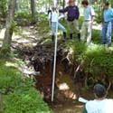
 Bar sample
A method of determining the composition of the stream substrate by taking a sample, sifting it through gradated wire screens, and weighing each sub-sample
to form a picture of the sizes of particles that make up the substrate.
Bar samples are taken on traverse bars and point bars; they give an indication of the bedload particle sizes that are transported during a bankfull
event.
Benthic macro-invertebrate
An animal larger than 1/2 millimeter that has no backbone, including crustaceans such as crayfish, mollusks such as clams and snails, aquatic worms and the
immature forms of aquatic insects such as stonefly and mayfly nymphs.
(Source: Maryland Department of Natural Resources.)
Channel-forming event
The storm event that causes the water to rise just to the bankfull elevation. Also called the bankfull event.
COE
The U.S. Army Corps of Engineers.
Cultural resources
A term encompassing archaeological sites (below ground remains of past human occupation), historic buildings (50 years of age and
older), and other historic cultural features (roads, wells, quarries, etc.)
Degradation
The act of downcutting and lowering of a stream bed. Degradation happens when the bed of a stream erodes more quickly (due to the force of the flowing water) than it can be
replaced by upstream sediment. Also called incision.
Degraded
Used generally, an adjective applied to sub-optimal streams. A degraded stream may have poor environmental functions, aesthetic qualities, and stability.
DEQ
The Virginia Department of Environmental Quality.
The size of a stream cross-sectional bankfull area.
Dredge
To mechanically remove sediment that has accumulated in a body of water.
Ephemeral stream
A stream that is driven by surface runoff and only flows during wet periods.
Eutrophication
Excessive plant and algae growth in a water body due to excess nutrients. Eutrophication in urban streams is often caused by fertilizer from lawns, golf course, and other landscaped areas.
Floodplain
The flat area of land adjacent to a stream which allows high flows to slow to non-erosive velocities.
Glide
The length of channel transitioning from a pool to a riffle.
 Headcut
A condition that occurs when water flows over a drop in the stream (caused by debris, sediment, utility crossings, etc) and causes scouring below the drop point. Due to the
erosive force of the water eating away at the streambed, the original drop point is eventually undercut and the headcut moves upstream, lowering the overall elevation
of the channel. Headcuts can range in size from a few inches to several feet, as seen in the picture to the right, which shows a 6-foot headcut on a small stream.
HUC
Hydrologic Unit Code. A unique 2- to 8-digit code that identifies the hydrologic unit in question. The HUC code for the NVSRB is 02070008.
(Source: U.S. Geological Survey.)
Hydrologic unit
A method of identifying an area with respect to its geographic drainage characteristics or unique hydrologic features. The United States is divided
and sub-divided into successively smaller hydrologic units which are classified into four levels: regions (largest), sub-regions, accounting units, and
cataloging units (smallest).
(Source: U.S. Geological Survey.)
Hydrologic unit code (HUC)
A unique 2- to 8-digit code that identifies the hydrologic unit in question. The HUC code for the NVSRB is 02070008.
(Source: U.S. Geological Survey.)
Incision
The act of downcutting and lowering of a stream bed. Incision happens when the bed of a stream erodes more quickly (due to the force of the flowing water) than it can be
replaced by upstream sediment. Also called degradation; incisions that travel upstream are known as headcuts.
Intermittent stream
A stream that flows during the wet parts of the year but does not flow during the drier parts of the year.
Longitudinal Profile
A drawing of the thalweg along the length of the stream. The longitudinal profile shows pools, glides, riffles, and runs along the stream.
Mitigation Banking
A market-driven system to provide compensation for off-site impacts, typically to streams or wetlands
Mitigation Banking Instrument (MBI)
A document providing an agreement between the Bank sponsor and the oversight agency (MBRT) to the Bank's parameters, design overview, and compensation credits.
Mitigation Banking Review Team (MBRT)
The oversight agency which approves or denies a Bank sponsor's request to create a bank, based on the MBI.
MOA
Memorandum of Agreement.
Northern Virginia Stream Restoration Bank (NVSRB)
A partnership between Wetland Studies and Solutions, Inc. and the Reston Association responsible for restoring and stabilizing streams in Reston.
NVSRB
The Northern Virginia Stream Restoration Bank. A partnership between Wetland Studies and Solutions, Inc. and the Reston Association responsible for restoring
and stabilizing streams in Reston.
Pattern
The shape a stream makes as seen from above or on a map.
Pebble count
A method of determining the composition of the stream substrate. Pebble counts can be done in riffles, on point bars, or along the longitudinal profile;
the results at each different area will disclose different information about the stream.
Perennial stream
A groundwater-fed stream that flows year-round, except in times of drought.
Phase I investigation
An archeological investigation to locate cultural resources and make a preliminary assessment of size, time period, and historic function. Phase I
investigations also include surface reconnaissance to locate artifacts that may be visible without excavation.
Phase II investigation
An evaluation of previously-delineated sites for historic significance and integrity.
Phase III investigation
An archeological investigation aimed primarily at data recovery.
Plat
A certified map showing the features (roads, building lots, easements, etc) of an area.
Pool
A channel feature characterized by deep, slow, flat water.
Profile
The shape of the stream bottom down the length of the stream. Also the shape of the channel cross section, from one bank to the other.
RA
The Reston Homeowners' Association. RA is responsible for maintenance and environmental protection of 1,300 acres of open space;
educational and recreational programming; the administration of the covenants related to the design and maintenance of property in Reston;
and issues which promote the peace, health, comfort, safety and general welfare of its members.
Reach
A length of stream between two defined points. A reach can be defined by road crossings, tributaries, or other hydrologically-distinguishing features.
Also called a stream reach.
Reference reach
A stable length of stream between two defined points. Reference reaches are used to determine optimum and stable channel dimensions, profiles, and
patterns for the restored stream.
Reference stream
A stable stream, used to determine optimum and stable channel dimensions, profiles, and patterns for stream restoration.
Reston Association (RA)
The Reston Homeowners' Association. RA is responsible for maintenance and environmental protection of 1,300 acres of open space;
educational and recreational programming; the administration of the covenants related to the design and maintenance of property in Reston;
and issues which promote the peace, health, comfort, safety and general welfare of its members.
Riffle
A channel feature characterized by shallow, swiftly-flowing water.
Run
The length of channel transitioning from a riffle to a pool.
Sediment
Soil particles, rocks, and pebbles that move with the water. Swiftly-moving water will entrain particles, while slowly moving water will deposit them; Reston's lakes currently
require dredging every few years because of the build-up of sediment from the stream banks.
Sedimentation
The process whereby sediment is deposited in a stream, which raises the invert of the stream bed. Can occur in wide, shallow streams because the water can not move quickly
enough to keep particles entrained.
Shovel test pit (STP)
A small, hand-excavated hole used by archeologists to locate cultural features. Soil excavated from the test pit is sifted through a wire
screen to allow any artifacts to be recovered. Shovel test pits are spaced at regular intervals over the area of concern.
Stream Bank
A market-driven means to provide compensation for off-site stream impacts.
Streambank
The sides of a stream, defined by an Ordinary High Water Mark.
Stream reach
A length of stream between two defined points. A reach can be defined by bridges, road crossings, tributaries, or other hydrologically-distinguishing features.
Also called a reach.
Thalweg
The deepest point along a stream cross-section. The thalweg at each step can be traced down the length of the stream to generate a longitudinal
profile.
Thunderbird Archeology
A division of Wetland Studies and Solutions, Inc. Responsible for conducting Phase I archeological investigations in the vicinity of the Stream Bank.
Time of Concentration
The time it takes for a fallen raindrop in the farthest portion of the watershed to reach the point in question. The time of concentration can include time
spent in sheet flow, shallow concentrated flow, and channel flow.
Tributary
A branch of a stream that flows into a larger section of stream. Sometimes abbreviated as "trib."
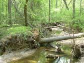
Undercut
A condition that occurs when water flowing through a stream erodes the lower portion of a bank so that the upper portion hangs out over the water.
Like headcuts, undercuts can be a few inches deep to several feet deep, depending on the underlying soils. Small undercuts can be beneficial by providing
fish and animal habitat, but large undercuts can be a dangerous condition, especially if they cause large trees with shallow root systems to overhang
the water. The weight of the trees will eventually cause them to fall, as seen in this photo.
Watershed
The area (including all overland flow areas, streams, rivers, and lakes) which drains to a specific point. The NVSRB will restore streams in three
watersheds in Reston: Snakeden, the Glade, and Colvin Run.
Wetland Studies and Solutions, Inc. (WSSI)
The Bank Sponsor for the NVSRB project. WSSI is the leading natural and cultural resources consultant in Northern Virginia.
|


