|
|
|
|
Home -- Design
The design of a stream restoration project is a lengthy process that involves many players, including archeologists, survey crews, GIS specialists, ecology specialists, and engineers.
In compliance with county and federal regulations, Thunderbird Archaeology undertook surveys for cultural resources on portions of the project, prior to the start of other stream restoration work. Survey for cultural resources - a term encompassing archaeological sites (below ground remains of past human occupation), historic buildings (50 years of age and older), and other historic cultural features (roads, wells, quarries, etc.) - is generally carried out in three stages. The initial step, a Phase I survey, is intended to locate resources and allow a preliminary assessment of size, time period and historic function (such as dwelling, camp, trash scatter, etc.). Subsequent phases of cultural resources survey include the evaluation of previously located sites for significance and integrity (Phase II) and data recovery (Phase III) to perform research on and record information from sites that cannot be preserved in place.
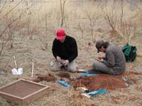
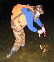
The primary method of the Phase I survey is the excavation of shovel test pits (STPs), relatively small, hand-excavated holes spaced at regular intervals. Soils are sifted through wire mesh to allow any artifacts to be recovered. Artifacts which are related in time and found in proximity to one another are the main criterion for delineating the boundaries of an archaeological site. Surface reconnaissance is also a valuable part of Phase I surveys, as historic features (such as foundations, roads, mill races, etc.) and surface artifacts may be visible without excavation. Other methods suited for particular locations (such as mechanical excavation in urban settings) or site types are also used in Phase I surveys.
Most of the land encompassed by the restoration project consists of floodplain within the stream valleys. An important part of conducting a Phase I survey in a floodplain is visual inspection of the topography and assessment of past stream dynamics. Some portions of floodplains are very unlikely to contain archeological sites, because streams move over time, removing soils and any traces of human occupation. More resistant features within or adjacent to the floodplain, such as dikes and terraces, may not be subject to stream movement and could therefore retain evidence of past human occupation.
Unfortunately, much of the development in the vicinity of the restoration project occurred prior to the routine inclusion of cultural resource surveys in the development process. The presence of buried utilities (sewer lines, water management systems, etc.) and other development-related ground disturbances lessens the possibility of finding intact archeological sites.
No artifacts were recovered near Snake Den or Colvin Run, and thus no archeological sites were defined. At the Glade, two small prehistoric sites were found (designated with state site numbers 44FX3228 and 44FX3229). A few quartz artifacts were recovered at each site, suggesting that stone tools were manufactured or reworked at both of the sites. No specific prehistoric era could be determined for either site, as no datable artifacts (such as projectile points or pottery) were recovered. The small number of artifacts recovered indicates that the sites were occupied for very short periods. In addition, the artifacts were recovered from soils which had been plowed in the past. Plowing disturbs archaeological sites by mixing horizontal layers, or strata, greatly lessening the quality of information which might be recovered through excavation. For these reasons, neither site was considered to be a significant cultural resource needing further archaeological investigation.
Initial Survey Control
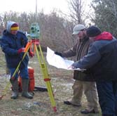
WSSI Surveyors were the first personnel on the ground at potential stream restoration areas in Reston. Our initial task was to establish a network of horizontal and vertical control to be used for aerial photography and photogrammetric mapping. Using Differentially Corrected Global Positioning System (DGPS) technology, approximately 250 control points were established and used to produce detailed topographic maps of the streams in the Snakeden, Colvin Run, and Glade watersheds.
After setting the aerial control, a more precise network of ground control was established using conventional traverse and leveling surveying techniques. This survey control allows our survey crews to perform precise measurement and location of features not visible from the air.
Ground-Based Surveys
The first survey task for our field crews was to perform detailed surveys of the streams requiring restoration. Profile surveys produced exact locations and elevations of the thalweg (centerline) of each stream. Cross-Sections determined characteristics of the stream banks. Visible utilities, including Sanitary Sewers, Storm Sewers, and Telephone, Electric, and Cable TV boxes were located.
In an effort to preserve and protect as many trees as possible, all trees with a diameter of 4 inches or more within 50 feet of the streams have been identified, measured, tagged, and located. To date, we have located approximately 30,000 trees.
Easements
The Survey Department of Wetland Studies and Solutions, Inc. has utilized all the information gathered in the field and conducted extensive land record research to produce and record Restoration and Temporary Construction Easement Plats and Deeds. The Restoration Easements created by The Reston Association and Cluster Associations provide permanent protection for the stream restoration areas. Temporary Easements allow WSSI to access, restore, and maintain the streams of Reston.
 The Geographic Information Systems (GIS) department at WSSI assembles spatial data to support all members of the stream restoration project team throughout the design
process.
The Geographic Information Systems (GIS) department at WSSI assembles spatial data to support all members of the stream restoration project team throughout the design
process.
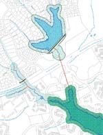
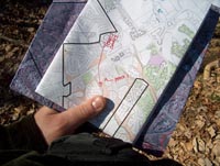
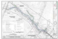
Our GIS specialists are responsible for creating maps that are used in project coordination, meetings, stream design and reports. They perform watershed delineation and average drainage area calculations for the stream design segments for use by the engineers, performing aerial photo interpretation to determine land cover and land use change over time within the watersheds for use by the engineers and archeologists, and creating base maps for field work by survey crews and ecology specialists. These base maps contain digital information purchased from Fairfax County that includes soils, parcels, hydrology, topography, roads, buildings, floodplains and Resource Protection Area (RPA) boundaries.
 The County map layers along with other map data such as digital USGS quadrangles, Federal Emergency Management Agency (FEMA) floodplain maps, ADC Street maps and National
Wetland Inventory maps are maintained and organized by the GIS department. This map data is used to create a variety of maps such as direction maps, property owner's map,
stream segment identification map, bridge location maps, easement and plat status tracking maps and the interactive map interface within this website. To further assist the
archeologists, the WSSI GIS staff acquires the Virginia Department of Historic Resources (VDHR) data on a quarterly basis and have scanned and geo-referenced over 750 historic
maps and USGS quadrangle maps dating back to 1751.
The County map layers along with other map data such as digital USGS quadrangles, Federal Emergency Management Agency (FEMA) floodplain maps, ADC Street maps and National
Wetland Inventory maps are maintained and organized by the GIS department. This map data is used to create a variety of maps such as direction maps, property owner's map,
stream segment identification map, bridge location maps, easement and plat status tracking maps and the interactive map interface within this website. To further assist the
archeologists, the WSSI GIS staff acquires the Virginia Department of Historic Resources (VDHR) data on a quarterly basis and have scanned and geo-referenced over 750 historic
maps and USGS quadrangle maps dating back to 1751.
The GIS department also maintains an extensive collection of in-house digital aerial imagery for the Reston area that includes photos flown in 1937, 1943, 1954, 1994, 1998, 2000, 2001, 2002, 2004, 2005, 2006 and most recently October 2007. The GIS department also stores and organizes a set of specially flown photography and 6 inch topography prepared for each watershed.
Our environmental scientist staff has been delineating the boundaries of the wetlands along the streams. The boundaries are marked with pink flagging, which has an alpha-numeric code, to assist our survey crew in locating the flags and the creating a map of the wetlands. Knowledge of wetland location will help us avoid impacting them during the construction of the stream restoration.
The goal of the post-construction and long-term monitoring program will be to collect data on the restoration of urban streams in order to advance the state-of-the-art of Natural Channel Design in urban/suburban areas of Piedmont, Virginia. Monitoring will occur during the growing season for up to 10 years and will allow proactive adaptive management techniques to be implemented in a timely manner to ensure that a successful stream restoration project results. The monitoring program includes riparian buffer monitoring and an assessment of biological conditions, as described below:
Riparian Buffer Monitoring
Sustaining a forested riparian buffer provides habitat and travel corridors for wildlife. Trees shade the stream, cooling the waters, which is beneficial for many aquatic organisms. The native trees and herbaceous plants help to reduce erosion by holding the streambank soil in place.
The reforested riparian buffer will be monitored pre- and post-restoration, and once during the 1st, 2nd, 3rd, 5th, 7th and 10th years following restoration. The buffer will be randomly sampled to ensure that there are at least 400 living woody stems (trees and shrubs) per acre, an herbaceous ground cover, and a density of woody stems of at least one stem every 5 l.f. along the streambank. Photographs will be taken at monitoring stations within the reforested riparian buffer to visually document changes in plant community structure.
Assessment of Biological Conditions
The diversity and abundance of biological organisms within a stream can help to determine the health of the stream. Certain species of benthic macro-invertebrates are very susceptible to water pollution such as chemicals and sediment; therefore, the presence of these species indicates a healthy stream. By monitoring what organisms exist pre-construction and in subsequent years following streambank restoration, we can evaluate changes in stream health.
The biological conditions (habitat) will be assessed along several stream reaches pre-restoration, and then in years 1, 5, and 10. We will perform a Biological Reconnaissance following the guidance established in the “Rapid Bioassessment Protocols for Use in Streams and Wadeable Rivers,” and we will calculate the Virginia Stream Condition Index (VA-SCI) following the guidance established in “A Stream Condition Index for Virginia Non-Coastal Streams.”
The Engineers at Wetland Studies and Solutions, Inc. (WSSI) have participated in the development of the Northern Virginia Stream Restoration Bank (NVSRB) since its inception in 2002. Specifically, the Engineering Department worked closely with Reston and local agencies to develop a Mitigation Banking Instrument (MBI). This document describes in detail the physical and legal characteristics of the bank, and how the bank will be established and operated. It also includes design as well as maintenance and monitoring requirements.
Before the MBI could be approved, WSSI engineers and staff worked closely with federal and state agencies to develop a “currency” (Stream Credit Units or SCUs) for assessing stream impacts and required mitigation. The resulting “Virginia Stream Impact Assessment Manual” (SIAM) developed by WSSI was approved by the U.S. Army Corps of Engineers (COE) and the Virginia Department of Environmental Quality (DEQ) for use in Phase I of the NVSRB. WSSI engineers and staff also amended Virginia law to allow the use of Natural Channel Design (NCD) concepts without having to comply with inappropriate and unworkable elements of the previous law (i.e., flow rate capacity and velocity requirements imposed on man-made channels, per §10.1-561 of the State erosion and sediment control program). Had WSSI not been successful in getting this law amended, the essential element of NCD that dictates that the stream be able to connect with its floodplain by overtopping its banks on approximately an annual basis would not have been possible.
Besides working with agencies to develop and approve the MBI, our engineering team has been working on numerous design tasks, including:
 Out in the field, WSSI engineers collaborated with our surveying team to develop a detailed existing conditions map of the streams. Engineers identified over 30 representative
cross sections to survey and collect sediment samples. Then they used the data in the hydraulic analysis of Snakeden Branch, which aided in establishing velocity and shear stress
thresholds. Over 20 sediment samples collected at representative point bars (the depositional feature inside meanders) within Snakeden Branch helped determine the largest size
particles moving through the system. Additional field parameters evaluated were sediment supply, flow regime, debris occurrence, depositional features, channel stability, bank
erodibility, and direct channel disturbances. All this data assisted in further refining our design protocol for Snakeden Branch.
Out in the field, WSSI engineers collaborated with our surveying team to develop a detailed existing conditions map of the streams. Engineers identified over 30 representative
cross sections to survey and collect sediment samples. Then they used the data in the hydraulic analysis of Snakeden Branch, which aided in establishing velocity and shear stress
thresholds. Over 20 sediment samples collected at representative point bars (the depositional feature inside meanders) within Snakeden Branch helped determine the largest size
particles moving through the system. Additional field parameters evaluated were sediment supply, flow regime, debris occurrence, depositional features, channel stability, bank
erodibility, and direct channel disturbances. All this data assisted in further refining our design protocol for Snakeden Branch.
The Engineering Department also set up 5 water level recorders and 2 rain gages that record water surface elevation and precipitation numerous times a day. The water surface elevations are compared to precipitation records to better understand how the stream responds to rain events of varying quantity and duration. Specifically, the data from the water logger established the size of the low flow portion within the restored channel. We have also installed an additional 9 water level recorders and 2 rain gages in the Colvin Run Watershed and the Glade.
To help us better understand how Snakeden Branch should be restored, 7 suitable “reference” streams (totaling 14 separate reaches) were found in the Northern Virginia area that had similar dimension, pattern, and profile and were in a stable condition. The reference data collected by WSSI compared well with published data collected in Maryland Piedmont streams. Thus, the published Maryland design curves were considered applicable to the streams in the NVSRB and were therefore used a basis for the design methodology.
In developing our design protocol, the Engineering Department also conducted a literature review. This included review and consideration of published regional curves as well as reports on urbanization and how it can result in downstream channel enlargement. Specific information reviewed as part of this analysis included (1) North Carolina Regional Curve Data, (2) Maryland Piedmont Regional Curve Data, and (3) Eastern United States Regional Curve Data.
Our engineering team also developed a detailed hydrologic model of Snakeden Branch to assess the applicability of flow rates generated by modeling standard NRCS design storms (1- and 2-yr, 24 hr, and Type II design storms) and to assess the potential impact of the restoration on the existing floodplain. The modeling provided insight into the magnitude of the flow rates experienced in Snakeden Branch. Our engineers used both the synthetic model and data obtained from our onsite water level recorders and rain gages to determine how storm events were moving through the watershed.
 Considering all the above data, our Engineering Department began the design of Snakeden Branch, starting with the most upstream reach (Reach 1 at Colts Neck Road) and working
downstream to Reach 17 at Lake Audubon. Once the restored cross sectional areas of riffles and pools along with the pattern and profile are confirmed, the project engineer
develops a detailed design plan set. The plan set includes our design concept, grading plans and construction details, erosion and sediment controls, planting schedule,
100-yr flood analysis, monitoring and maintenance requirements, and all temporary grading and stream restoration deeds and easements.
Considering all the above data, our Engineering Department began the design of Snakeden Branch, starting with the most upstream reach (Reach 1 at Colts Neck Road) and working
downstream to Reach 17 at Lake Audubon. Once the restored cross sectional areas of riffles and pools along with the pattern and profile are confirmed, the project engineer
develops a detailed design plan set. The plan set includes our design concept, grading plans and construction details, erosion and sediment controls, planting schedule,
100-yr flood analysis, monitoring and maintenance requirements, and all temporary grading and stream restoration deeds and easements.
Engineers are also responsible for submitting to Fairfax County and coordinating the approval process. We also coordinate with the Reston Association, specifically submitting a Design Review Board (DRB) Application and notifying all adjacent property owners of the proposed stream restoration. We present each plan set to DRB for approval. We also help answer questions about the project by attending local Homeowner’s Association meetings.
After approvals from the Reston Association, Fairfax County, COE, and DEQ, engineers prepared construction bid packages for contractors. When construction starts in February 2008, the Project Engineer will provide guidance during the construction phase.
|


